Austria-Via Ferrata Sinabell

Tour description
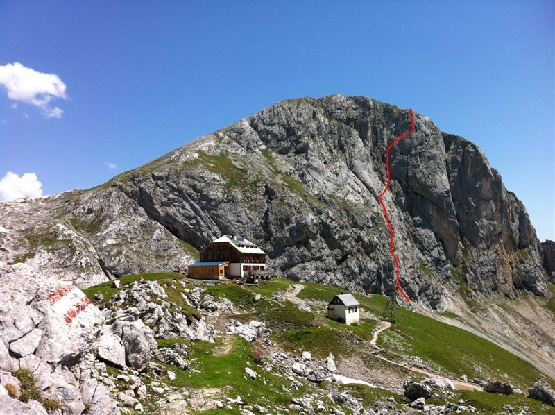
Sinabell's impressive southwest-facing wall can be seen from afar. At the summit, an alpine meadow, filled with flowers and grazing sheep, invites you to take a break with wonderful views across mountaintops from the Enns Valley and the Schladminger Tauern to the high-alpine terrain of 'Am Stein'.
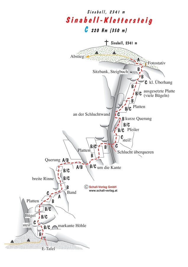
Due to some very consistent passages at grade C, the via ferrata appears somewhat more challenging, especially for less experienced via ferrata climbers. As a day trip from the valley, the via ferrata is quite demanding due to the long approach with over 1,000 meters of elevation gain. However, with an overnight stay at the Guttenberghaus, it's a pleasant half-day tour and can easily be combined with the via ferratas on the Eselstein.
Times:
- Via Ferrata - 1:15 h
- Time to Base - 3:15 h
- Time from Top - 3:00 h
- Total - 7:30 h
The tour
Map, elevation profile & further information
Arriving from the west: From the west you can take the Munich-Salzburg motorway, continuing on the Tauern motorway (A 10) until the Ennstal junction. From here take the Ennstal A-road (the B 320) for around 30 km into the Schladming-Dachstein region, then take the Ramsau am Dachstein turn-off. Continue to the Ramsau plateau and about 1 km after Ramsau Kulm turn right to Rössing street (Rössingstraße) and continue junction (Abzweigung) Feistererhof.
Arriving from the north and east: From the south-east take the Pyhrnautobahn motorway (A 9) to the Liezen junction and then the Ennstal A-road (B 320) into the Schladming-Dachstein region. Then take the Ramsau am Dachstein turn-off. Continue to the Ramsau plateau and about 1 km after Ramsau Kulm turn right to Rössing street (Rössingstraße) and continue junction (Abzweigung) Feistererhof.
The starting point can be reached by bus line 962 of the Ramsau public transport company - stop "Berghof/Abzweigung Feisterer" - about a 10-minute walk to the Feisterer trailhead.
The Feisterer hiking portal can be reached in about 20 minutes from the Stierer stop on Ramsau public transport line 960.


