Gröbminger Land
Hangofen über Englitztal
Hiking trail
Data:

Tour description
The Walchental is a secluded and historically significant valley where mining once took place; today, guided tours are still offered along the Copper Trail and at the new Öblarn Water Experience.
The hike to the Hangofen leads from the ÖAV Berghaus through the Englitztal and the Ober-Englitztal to the summit. The final section of the hike requires sure-footedness and a head for heights. From the Hangofen, there are additional rewarding summit destinations to the east and west.
The hike to the Hangofen leads from the ÖAV Berghaus through the Englitztal and the Ober-Englitztal to the summit. The final section of the hike requires sure-footedness and a head for heights. From the Hangofen, there are additional rewarding summit destinations to the east and west.
The tour
difficult
Starting and end point
Mountain Lodge in Walchen
Tour characteristics
Distance: 12.4 km
Fitness (4/6)
Skills (5/6)
Information
Distance: 12.4 km
Duration:
5:00 h
Ascent: 1050 m
Descent: 1050 m
highest point: 2056 m
Best season
Jan
Feb
Mar
Apr
May
Jun
Jul
Aug
Sep
Oct
Nov
Dec
Map, elevation profile & further information
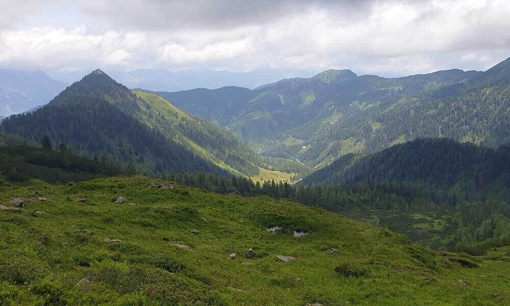
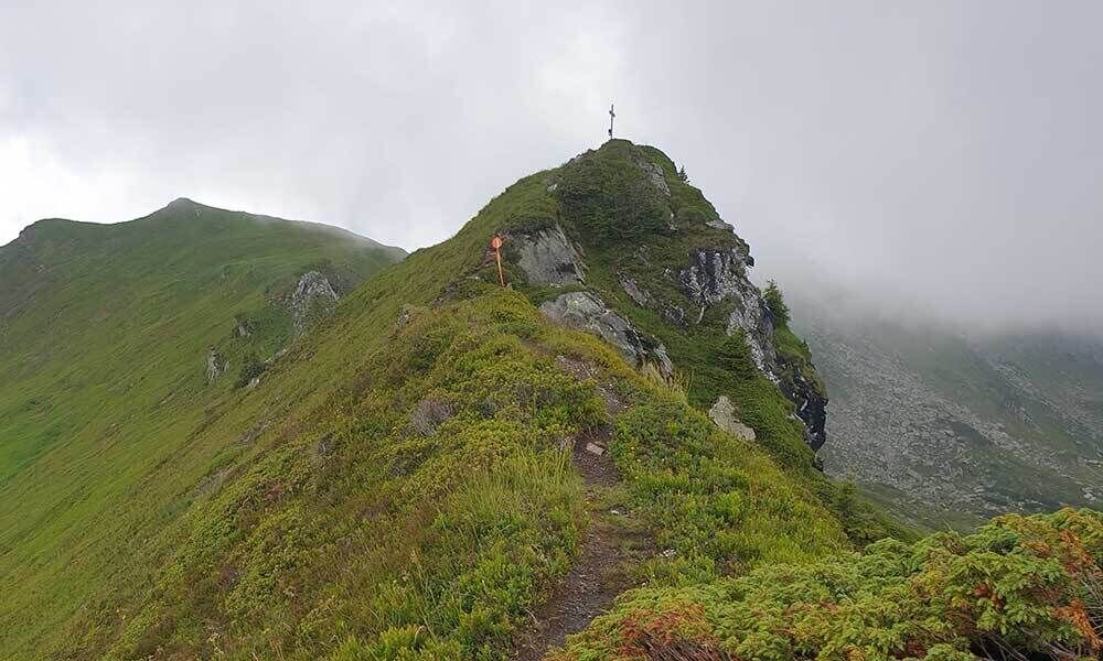
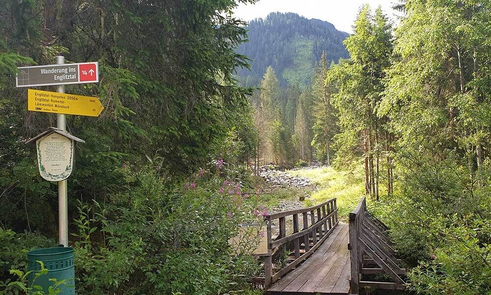
The tour starts at the ÖAV mountain hut. From there, cross a small bridge and follow the signs past the Weiße Wand quarry until you reach the Englitzalm (1,322 m). Continue south across the alpine pasture to the end of the valley, then ascend via steep switchbacks over a rocky ledge, past the hunting lodge (1,605 m), into the upper Englitztal. The Hangofen rises high above the mountain pine-covered plateau, crisscrossed by small streams. Cross the plateau heading south, then ascend a steep but well-maintained trail to the ridge east of the Hangofen. From here, the route climbs the steep, south-facing meadow slopes to the summit cross at 2,056 m.
Caution: To the north, the Hangofen drops almost vertically, and the final section of the trail is narrow and somewhat exposed.
Further options along the Styrian Regional Hiking Trail lead westward (Plöschmitzzinken 2,095 m and Kühofenspitz 2,145 m) and eastward (via the Lämmertörlkopf 2,046 m and the Lämmertörl 1,920 m through the Ramertal back to the Englitzalm).
From the A10: At Altenmarkt (Exit 63), turn toward Graz. Follow the B99 to Radstadt. From there, take the B320 toward Graz. At Pruggern, follow the sign for Öblarn.
From the A9: At Selzthal (Exit 69), turn toward Liezen/Radstadt. From Liezen, take the B320 to Espang. There, turn toward Öblarn.
For the hike: From the center of Öblarn, head toward Walchen (swimming pool). The Walchen Valley is a dead-end valley. From the swimming pool, it’s about 6 km to the parking lot at the ÖAV mountain hut.Mountain Lodge in Walchen
In September in particular, please pay attention to the signs regarding hunting and the associated restrictions on hiking.
Weather changes, rapid drop in temperature, thunderstorms, wind, fog and snow fields are objective dangers and require the right behavior on the way. Hut keepers are experienced mountain connoisseurs, they can give good tips on the weather and the course of the trail. Lack of equipment, overestimation of one's own abilities, carelessness, poor physical condition and a wrong assessment can lead to critical situations. During thunderstorms: avoid peaks, ridges and rope belays at all costs.
GPS data and orientation aids: Available GPS data - as well as hiking maps - are only an orientation aid, since they can never represent an exact image or the richness of detail of a path in reality. Especially in the case of danger spots, it must therefore always be decided in the end on the basis of the conditions on site whether and how the further course of the path looks like.
In case of emergency, please dial the following emergency numbers:
No. 140 - for alpine emergencies - Austria-wide
No. 112 - Euro emergency call GSM emergency call service
Take rainproof and warm clothes and enough water, possibly also a snack, wear shoes with non-slip profile soles. A first aid kit should also be in your backpack.
SummitLynx- Your digital summit and hut book - available worldwide and always with you!For more information, please contact the Schladming Dachstein Tourist Office:
Phone: +43 3687 23310
mailto:info@schladming-dachstein.at
The brochure “Schladming-Dachstein Hiking” is available in all information offices in the region.
Phone: +43 3687 23310
mailto:info@schladming-dachstein.at
The brochure “Schladming-Dachstein Hiking” is available in all information offices in the region.


